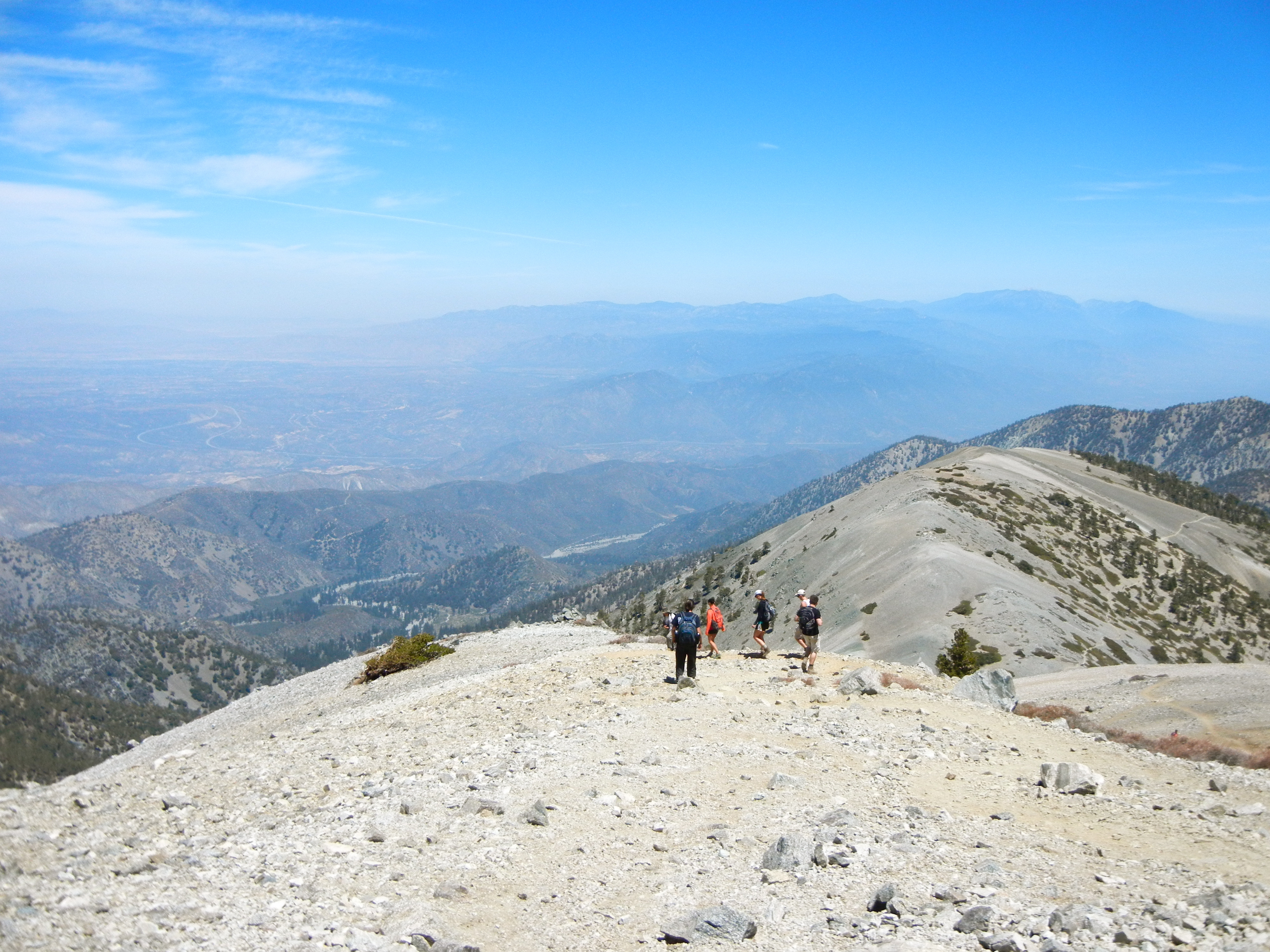
Mt. Whitney


14,505 ft. of mountain. 12268 ft. of elevation change. 21.7 miles. 1 very long day.
You must start before the sun comes up. We hit the trail at 3:30 AM, which was pretty great because we did the first 4 miles in the dark while half-asleep and it is much easier to have no idea how hard you’re working under these conditions. By 7:30, we’d gone the 7ish miles to Trail Camp.
We thought, “We’re kicking this trail’s ass, we’ll summit by 11:00 at this pace!” We had come prepared with headlamps, iodine, moleskin… the usual hiker must-haves, but we had not prepared for the Switchbacks (dun dun dun). It’s probably best that we didn’t know about them because it would have been impossible to mentally prepare for the combination of elevation, distance, incline, and acrophobia.
So, the switchbacks begin. This 1600 foot ascent that covers about two miles took around 2.5 hours. It’s not just that you’re climbing, it’s that you start the climbing at 12,000 feet after having already been hiking for 4 hours. And after you reach the top, it’s another 2 miles or so across a traverse between 13,500 and 14,000 feet before your final 500 foot ascent to the top. Before the final ascent, passers-by like to tell you, “You’re almost there!” so you start expecting a celebratory marching band and a round of applause after every turn, which was neither possible in this realm of reality nor true in its report of remaining distance. But, I suppose it’s all relative.
The only other 14ers I’ve summitted were in Colorado where tree line ends around 11,700 feet and then arctic tundra begins, so there are signs of life all the way to the top. In reflection, what stands out most about this hike is how for the great majority of it you walk across a rocky, barren terrain. But, while in the moment of hiking this mountain there isn’t just one thought that dominates because between the views, the blisters, the fellow hikers, and the “I’m the king of the world!” effect, your mind is busy the entire day. That is, until the end when you can’t think, can’t talk, and can’t move. Unless, of course, you’re choosing a restaurant, ordering dinner, and shoveling food into your mouth.
J.A.M. Sessions


J.A.M. Sessions began in 2008 at the John Anson Ford Amphitheatre. The idea is that these events are both free and participatory. The Ford’s summer series is put on by the Los Angeles County Arts Commission, which has an entire program called “Free Concerts in Public Sites.”
These free concerts have expanded in the last 5 years and now there are free J.A.M. Sessions in 5 locations throughout the county, from Newhall to Watts.
On the steps of the venue was a jam session lead by Ben Guzman of Triple Chicken Foot, and on the stage of the Egyptian influenced deco stage was a square dance called by Susan Michaels. Though the 1200 seats were mostly empty, there were over 50 dancers hooping and hollering around the 93-year-old theatre’s stage.
For more about J.A.M. Sessions check here: http://www.fordtheatres.org/en/events/category/id/37
4th of July Parade: Chester, CA


I didn’t intend to attend a small town 4th of July celebration. After solo camping at Juniper Lake in Lassen Volcanic National Park, I could’ve only hoped for a coffee shop to be open on the holiday as I travelled from Lassen down to Quincy for the High Sierra Music Festival. Thankfully, I found so much more than coffee.
While enjoying a pre-parade Bloody Mary at the local tavern, I spoke to a man who grew up in Plumas County and currently resides in Sacramento. There, he works in office furniture installation, but he aspires to work in sports management. Using my girly charms, I learned that being a high school student in Plumas County is not so different than being a high school student anywhere else- you spend most of your time blaming all your problems on geography and then you grow up to realize that home isn’t half bad. I also learned that the two largest employers in Plumas are the US Forest Service and the local mill.
My back hurt from so many nights sleeping on the ground, so I hung in a forward fold (uttanasana) in the street before the parade began. An older woman came over to me and said, “That looks like it feels good. What are you doing?” As an over-eager recently certified yoga instructor, I aided her into the low back release. It is fair to say that she was at-risk for Type 2 diabetes, but she informed me that she had recently started going to Curves and she was enjoying feeling in control of her body again. As she rose from her forward fold, I noticed she was wearing a Tea Party tee-shirt. This is when I was reminded that being an American is complicated.
We can’t agree if government is responsible for our health or our education or our privacy, but we do believe in freedom. I guess we also mostly believe that day drinking, abiding by a certain color scheme, listening to a certain classic rock genre, and putting our karate educated youth on display is an appropriate way to celebrate that freedom.
As I waited for the parade to begin (can you tell there was a lot of waiting for the parade? People put their lawn chairs out before I rode through town at 7 AM, the parade began at 11 AM, and it lasted for about 30 minutes. The wait-time to parade-time ratio was significant), a man offered me his spare lawn chair. He was probably a Tea Party member as well, but it didn’t matter if he was red and I was blue, or green, or none of the above because we were able to be grateful to be American, together. We also worked as a team to collect candy thrown by parade participants for his grandchild like it was a patriotic Halloween.
Mt. Baldy


We ascended this 10,064 ft. peak via the Baldy Bowl Trail (otherwise known as the “Ski Hut Trail”), which starts at Manker Flats and, shortly after diverging from the San Antonio Falls Trail, begins to scale the side of the mountain. The rapid ascent means the king-of-the-world motivational factor sets in quickly, but it also means the strain in your glutes sets in quickly. You gain nearly 4000 feet of elevation in 4 miles. When we arrived at Manker Flats, we were like, “That was such a short drive. Why have we never been here before?” But by mile 3, we learned the answer to our question.
That being said, this was probably the most beautiful hike I’ve done in Southern California. You weave your way through Jeffrey Pine, scale your way through a Lodgepole forest, and get far-reaching views of the Antelope Valley, the San Gabriel Valley, and the San Gabriel range. And we weren’t even hiking on a clear day! I’ve heard rumor you can see all the way to the ocean if you plan your trip according to the skies.
Okay, so on our way down we took the Devil’s Backbone route to the ski lodge. There, we learned that an excellent option to experience the magic of Mt. Baldy might be to simply take the ski lift from Manker Flats to the Top of The Notch where you can sit on a dining patio with a burger and an IPA. But, as pleasant as that might be, you wouldn’t get to rise above tree line (the very root of why we call the peak “bald”) and you wouldn’t be able to say you’ve been to the highest point in Los Angeles County.
Loquats


He’s gone to smell the loquats…
Funny how even without context it’s still pretty clear what that means. That turn of phrase grew common in China where they once referred to brothels as “the gates of loquats” because the loquat blossoms smell so delicious. The trees grow rampant across this city, but people don’t seem as excited about them here as they might be in China. Maybe we just don’t know what they are or maybe we just don’t own a tall enough ladder to reach the fruit. Either way, if you put in the effort you’ll find a sweet stone fruit, not a citrus as its name’s likeness to the kumquat might imply. “Quat” means orange in Cantonese. Kumquat: golden orange. Loquat: reed orange, meaning the tree likes to grow where it’s swampy like a reed.
Korean Bell of Friendship


You know those places outside of national parks where they claim there’s a special magnetic force field and they create optical illusions to prove the existence of said force field? Okay, the Korean Friendship Bell is a force field even though they do not advertise it as such. Additionally, I don’t know that the magic seeps from the Friendship Bell itself, I think they chose a magical location for the bell.
This Angel’s Gate Park plateau overlooks the ocean, the harbor and a splice of Palos Verdes. There’s a strangeness to it all, and there’s a celebration of freedom and of gratitude. One might even want to call it a west version of the Statue of Liberty, after all it was given to the United States to celebrate our bicentennial. But while the Statue of Liberty weighs 225 tons, this metal emblem of freedom only weights 17.
In this particular case, size does not matter and a day at the park with a kite and a picnic is well spent at this San Pedro pagoda. For more info, check here: http://www.sanpedro.com/sp_point/korenbel.htm
Coral Trees


 Even though “Hollywood” montages of Los Angeles show palm trees galore, the official tree of Los Angeles is the Coral Tree. I always assumed we called it “coral” because of the color of its flowers, even though that never really made sense because the flowers are red, not coral. My second guess, still related to the flowers, was that because they are clustered in inflorescence, it kind of looks like sea coral. Wrong again! The name comes from the fact that their branches look like sea coral. But, when a tree has such vocal flowers, who’s paying attention to the branches?
Perhaps the most impressive stand of Corals in the area is along San Vicente between the VA and the beach. There are about 120 trees planted along 5 miles of the ex-Red Car median. They were planted sometime after WWII. In 1976, they became a historic-cultural monument. In 2013, Brentwood residents are fighting to raise funds for the trees’ maintenance. Learn more about their campaign here: http://www.brentwoodcommunitycouncil.org/resources-links/our-coral-trees
Holi Festival of Colors


St. Patrick’s Day dominates the American mid-March holiday scene. The holiday, imported from Ireland, places the color green at the focal point of its festivities. Holi Festival of Colors, however, is imported from India and celebrates every color. Well, technically the festival celebrates that the hero of Holi’s story, Prahlada, was set to fire in a pyre on the lap of his aunt, Holika. Holika burned to death and Prahlada survived. I don’t know enough to tell whether we’re celebrating the death of Holika, the survival of Prahlada, or if spring is just a really good time to throw colored chalk on a bunch of strangers. But, what a great idea for a holiday!
For more information on Los Angeles’s celebration, check here: http://www.festivalofcolorsla.com/
Murphy Ranch


Murphy Ranch, more commonly known as the “Nazi Bunker,” sits in the hills of the Pacific Palisades. It’s creepy because had Germany won WWII, this is supposedly the place where Hitler planned to rule the world. With a 375,000 gallon water tank, a diesel power plant, and many other amenities, this estate could’ve harbored a world fascism headquarters for an uninterrupted year. To the misfortune of worldwide fascist domination, construction on the ranch was interrupted by the federal government the day after Pearl Harbor.
In 2013, it’s perhaps a comical ruin of what never was. Hidden in LA’s 6th richest census tract and watched over by the Santa Monica Mountains Conservancy, it has become home to local hooligans… beer cans scatter the grounds and graffiti covers every inch of poured concrete. This current narrative fits in more with the area’s history. After all, just down the creek from Murphy Ranch is the former Uplifters’ Clubhouse where bohemians hid out during Prohibition to keep the party going.
Despite its hidden nature, access is pretty simple. If you go up Capri from Sunset, you turn right on Casale Road and just park wherever you can, so thank you benevolent Palisades homeowners for letting us use your street parking. Anyway, if you turn back west an head down the road it will turn into Sullivan Fire Road. After a short while, the gates to the estate will appear. When there’s a fork in the road, turn left to find an unruly amount of stairs. Good for simplicity’s sake, and good for sculpting your butt.
February Skies


Today, they predicted thundershowers. I received text messages from friends saying, “Have you noticed it’s a rather blustery day?” And my roommate ran around our unheated apartment yelling, “Why is it so cold?” The other day I got on the bus and, though I try not to spread negativity, it felt necessary to exclaim to the stranger next to me, “It’s freezing out there.” He, in all his Frenchness, responded, “Well, it’s February.” Though I may complain, if February keeps bringing skies like this, I say, “Keep ‘em coming!”

